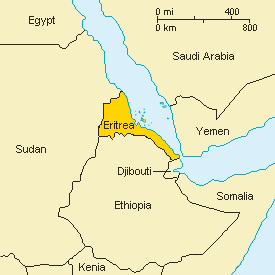
Eritrea is located in the Horn of Africa. The capital city is Asmara.
It is bordered by Sudan to the north and west, Ethiopia to the south, Djibouti to the south-east and the Red Sea to the north and north-east. Eritrea derives its name from the word 'erythro' which is an ancient Greek term for red since it is located by the coast line of the Red Sea.With a land area of about 125.000 km2, Eritrea is about the size of England, or the state of Pennsylvania in the USA. The coastline measures around 1.200 km and off it there are over 350 islands, of which 210 comprise the area of the Dahlak Archipelago.There is an eight hour time difference (ahead) between USA Eastern Standard Time and Eritrea, which is reduced to seven during Daylight Savings Time.
| Land boundaries | 1,630 km |
| Djibouti | 113 km |
| Ethiopia | 912 km |
| Sudan | 605 km |
| Coastline | 1,200 km |
| Land + island coastline | 2,234 km |
 |
No comments:
Post a Comment